Covering

Previously called 'Things I Have Seen', this project is about 'Covering' an entire city through walking. Right now, we're focussing on my hometown in the Netherlands, Amersfoort, but who knows what cities we'll cover after this one?
Rules
- Legality
Only walk streets and paths where pedestrians are legally allowed. - Coverage
Each street only has to be walked once. - Functional Equivalence
Where two parallel streets serve the same function (e.g., a main road and its service road), walking one is sufficient. Parallel streets separated by a block or more must each be walked. - Pedestrian-Only Streets
Pedestrian-only streets are generally excluded, except when:
- The street has an official street name, and
- It provides access to the front doors of multiple residences or buildings.
Singular unnamed paths or private driveways are not required.
- Access Restrictions
Streets blocked by signs such as No Entry, Private Property, or similar are excluded. Temporary closures (e.g., construction, events) should be revisited later.
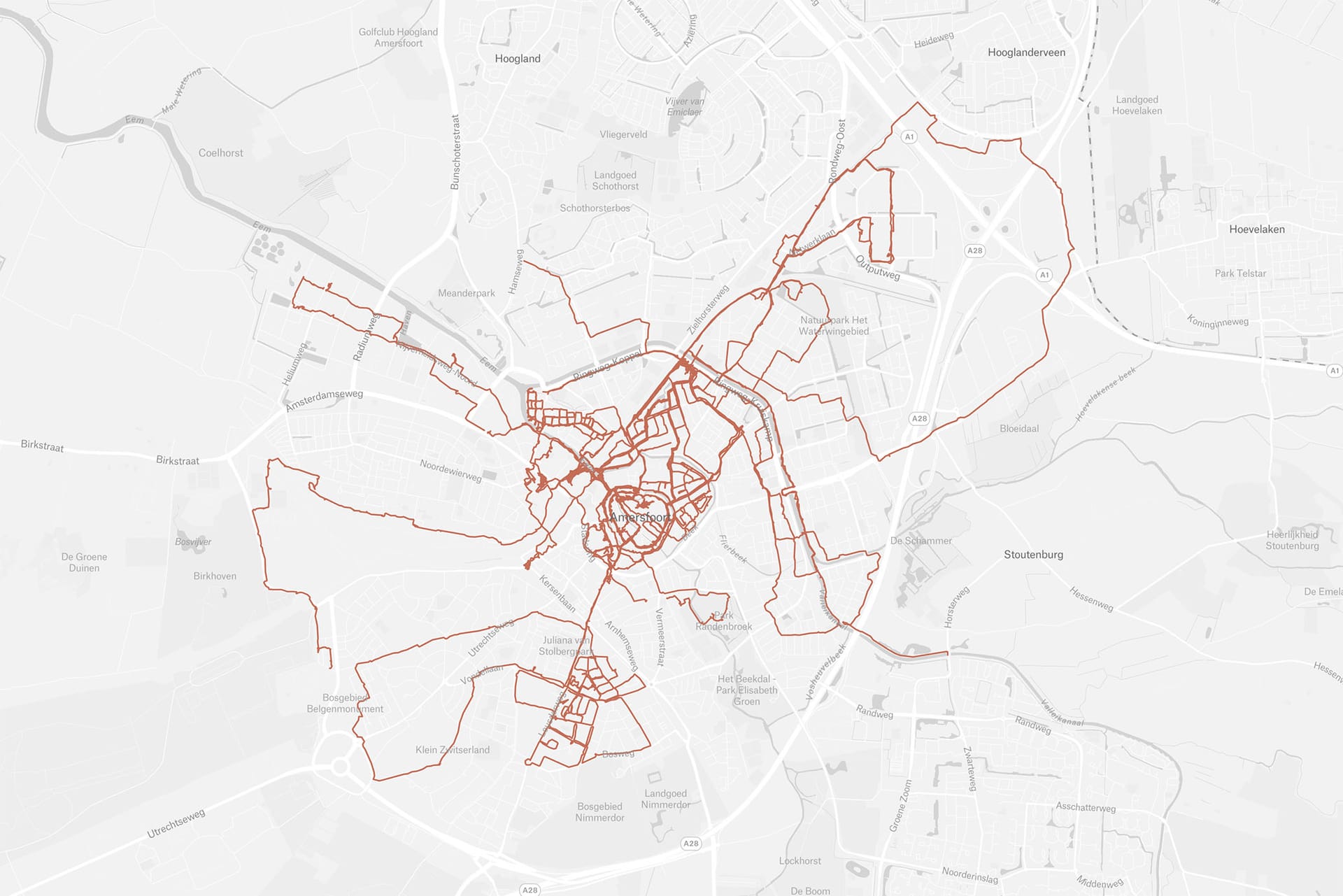
Amersfoort
Curious to see my progress? The map below is an interactive and live (meaning I update it after every walk I do) overview of where I've been so far. More details coming soon.
Images
Unfiltered, unopinionated, unfinished. Every images shot on the streets of Amersfoort, with coordinates attached, of course, lives in this folder in my online photograph archive. For now. Enjoy!
Video diary
My walks are documented in short form videos. You can find the most recent episode below, as well as all the other ones in de the dedicated playlist on YouTube.
L'Estartit
Where Amersfoort is a long-term commitment, L’Estartit, a small town on the Costa Brava, was a contained moment. A place entered briefly, walked fully, and then left behind. Basically just to see what a complete cover 'looks like'.
Over the course of my stay, I walked every street of the town. No optimization, no shortcuts. Just moving through it until the map closed in on itself. The result is a complete record: streets traced, distances walked, photographs made along the way. A finished loop.
Images
The work here is done. The map is filled. What remains is the images and the feeling of having been somewhere.
Just you, me, and some occasional notes from the field. No spam.
Member discussion